 Brochures
 Enquiries
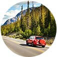


Alberta is many things to many people: Wild West province, prairie province, home to Canada’s Rocky Mountains. To us, it’s simply spectacular.
In Alberta you’ll find those wide-open roads that lead you to the Canada you imagined. Think towering peaks, turquoise glacial lakes and more wildlife than you can shake a campfire, marshmallow-laden stick at.
That’s why Alberta is the perfect province for a road trip. Hire a car or a luxurious campervan and hit the road to see some of the most incredible sights in Canada.
Here are our favourite 10 driving routes in Alberta that you just can’t miss:
10. The Cowboy Trail

Where: From Mayerthorpe (about 85 miles outside of Edmonton) to Lundbrek (130 miles south of Calgary) on Highway 22
What: Huge skies and prairie vibes in the foothills of the Rocky Mountains. There is plenty of Old West charm en route.
How long: 355 miles
Top stops: Chain Lake Provincial Park offers tranquil lake views, swimming, camping and fishing for rustic adventurers. Bar U Ranch National Historic Site is bursting with history from the era of horse-drawn wagons, ranches and cowboys.
9. Trans-Canada Highway from Lake Louise

Where: Lake Louise to Revelstoke on Highway 1
What: The Trans-Canada Highway is a 4,860-mile road that spans the entire breadth of Canada, from the Atlantic to the Pacific. Driving all of it would be a little crazy, so we suggest the beautiful section from iconic Lake Louise to Revelstoke, which is actually in British Columbia, giving you a sneak peak of the province next door.
How long: 140 miles
Top stops: Ride the Lake Louise Gondola for one of the best ways to spot black bears (not to mention spectacular views of the turquoise lake itself). Glacier National Park is a must-stop for an alpine hike.
8. The Canadian Badlands

Where: Calgary to Dinosaur Provincial Park via Highway 1
What: A Wild West landscape where the Jurassic meets the cowboy rancher in a dramatic series of hoodoos, banded hills and the best rock formations this side of the Grand Canyon.
How long: 136 miles
Top stops: Dinosaur Provincial Park is a UNESCO World Heritage Site thanks to the abundance of incredibly preserved dinosaur fossils (including T-Rex’s of course!) You can extend your road trip up to Drumheller to see the Royal Tyrell museum and it’s amazing palaeontology collection.
7. Smith Dorrien Spray Trail

Where: Kananaskis Country from Ozada to Banff via Highway 40 and the Smith Dorrien Spray Trail
What: Forget Highway 1. Leave the beaten track outside of Calgary just as you get to the foothills of Kananaskis Country. This backdoor, gravel road is an epic adventure through moose country, alpine trees and snow patches (even in summer).
How long: 72 miles
Top stops: Stop off at the Spray Lakes for a picnic and keep your eyes peeled for moose, elk, mountain goats and even the occasional bear.
6. The Boomtown Trail

Where: Calgary to Edmonton via the roads less travelled
What: Take the backroads, avoiding the Trans-Canada Highway and major routes, and you’ll be rewarded. This backwater route livens up what could be a boring drive between Alberta’s major cities. This way, you can take in scenery and pioneer towns.
How long: 246 miles
Top stops: Buffalo Lake is a gorgeous spot for a paddle and a cool-down. Swing by Donalda to see the world’s largest lamp!
5. The Dinosaur Trail

Where: The North and South Dinosaur Trails from Drumheller
What: It’s only a short loop around Drumheller but the landscapes are spectacularly barren and dramatically bleak.
How long: 30 miles
Top stops: Stop by the Horse Thief and Horseshoe Canyons which were carved out by the Red Deer River.
4. The Crowsnest Highway

Where: Fort Macleod to Crowsnest on Highway 3
What: This highway stretches from Southern Alberta almost to the British Columbia borer. It has great scenery and a lot of mining history, encapsulated in the charming towns along the way.
How long: 68 miles
Top stops: Stop off at the little community of Burmis to take a photo of the Burmis tree – reportedly the most photographed tree in Canada! Its bare, twisty branches make for a dramatic silhouette.
3. The Bow Valley Parkway

Where: Banff to Lake Louise on Highway 1A
What: What this driving route lacks in length, it makes up for in beauty. The mountain town of Banff and the iconic hamlet of Lake Louise are scenic in themselves, but this stretch off the main highway follows the mighty Bow River. It forces you to go slow, but that means you have time for the scenery.
How long: 35 miles
Top stops: See the dramatic peak of Castle Mountain from different angles along the route – including from underneath. Pull up anywhere along the road to watch out for elk.
2. Sunwapta Pass

Where: The border between Banff and Jasper National Parks
What: Technically part of the Icefields Parkway, Sunwapta Pass deserves its own special mention. It’s the second-highest drivable pass in Banff and Jasper National Parks after Bow Summit, at an elevation of 6,742 feet.
How long: The length of time it takes you to hold your breath and then let it out in a slow sigh of awe
Top stops: The Sunwapta Pass is the low point of the saddle created between Mount Athabasca and Nigel Peak, so look out for both as you drive past.
1. Icefields Parkway

Where: Lake Louise to Jasper along Highway 93.
What: 144 miles of arguably the most spectacular scenery in Canada. So many of Canada’s famous attractions are located along this stretch of road. It’s a particularly good place to spot black bears and bighorn sheep by the side of the road.
How long: 144 miles
Top stops: The Athabasca Glacier is the most easily accessible of the six glaciers fed by the Columbia Icefield. The best way to experience the glacier is to do the bus tour – a specially adapted Glacier Explorer bus takes you out onto the face of the glacier itself, where you can drink 10,000-year-old meltwater. Other great stops are eye-popping Peyto Lake, tranquil Bow Lake and dramatic Maligne Canyon.
